Vancouver, British Columbia / August 29, 2023 – Xander Resources Inc. (“Xander” or the “Company”) (TSXV: XND) (OTCPK: XNDRF) (FSX: 1XI) is pleased to announce it has completed the 2023 geological mapping and soil sampling program at the Company’s Senneville Project...
May 26, 2021 – Xander Resources Inc. (TSXV:XND) (FSE:1XI) (OTC:XNDRF) (” Xander ” or the ” Company “) is pleased to announce that the Fenelon Blue Ribbon 2020 fall channel sampling program in the Abitibi Greenstone Belt has identified Gold occurrences. Four trenches were excavated for channel sampling and 39 samples were taken for analysis in the 2020 Fall Program at the site of a historical gold showing. Fire assay results from Val-d’Or ALS Geochemistry Analytical Labs returned values of up to 1.42 g/t Au in quartz-ankerite .
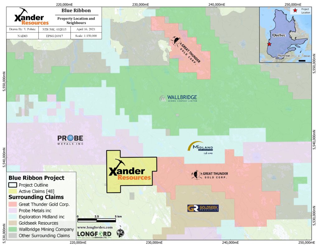
The Blue Ribbon Property is in the Fenelon Gold Camp and is comprised of 48 claims including Xander’s Blue Ribbon Property extension of 9 claims that were added in 2020 to protect the historic gold showing reported on by J. Remick. (Remick, J.H., 1969 RP 564(A) p. 20). The Blue Ribbon Property is located approximately 11 km southwest of the Wallbridge Mining (TSX:WM) Fenelon Mine Project and borders Probe Metals (TSX.V:PRB) , Midland Exploration (TSX.V:MD) and Great Thunder Gold (TSX.V:GTG).
The original gold showing reported on by a Quebec Government geologist Remick, J.H. in 1969, was found in Xander’s 2020 fall ground exploration program. Additionally, several old trenches were found where Remick had previously noted a trench that exposed one hundred feet (30.5 meters) zone of quartz-ankerite veins in sheared diorite. The shear zone carried small amounts of pyrite and chalcopyrite with visible gold observed in quartz veins and no assays were reported. (Remick, J.H., 1969 RP 564(A) p. 20). In 1986 at this same location Quebec Government Geologist S. Lacroix, sampled a width of 0.76 meters resulting in an assay of 8.5 g/t Au .(Lacroix, S. 1987 DP87-13, p.7).
The Blue Ribbon Property
The Blue Ribbon Property consists of 48 claims which cover approximately 1,885.25 hectares (18.88 km 2 ). Access to the Blue Ribbon Property is by Road 810, Highway 109, and thereafter by a series of logging roads. The northern portion of the Blue Ribbon Property overlies the Broullian-Fenelon Group of rocks, which is comprised of felsic to mafic volcanics and sediments and is located in the northernmost greenstone segment of the Abitibi Sub-Province, a region which is underexposed and underexplored. The southern part of the Blue Ribbon Property overlies the northern edge of the Broullian Intrusive Complex. The intrusive/volcanic contact is coincident with the west-northwest trending Bapst Fault. The Bapst Fault trends NW-SE through the Blue Ribbon Property and is characterized by brecciated and sheared dacite, often with disseminated pyrite.
There are many gold and base metal occurrences within the Broullian-Fenelon Volcanics on the south side of the Broullian Intrusive Complex, including the former Selbaie Mine. The eastward extension of the Lower Detour Deformation Zone/the Grasset Deformation Zone is located just to the north of the Blue Ribbon Property. The Bapst Fault which extends the length of the Blue Ribbon Property may be a splay or bifurcation of the Grasset/Lower Detour Deformation Zone.
Regional Potential
The combination of the major Bapst Fault, the intrusive/volcanic contact, the unexplored Broullian-Fenelon volcanic/sedimentary package and the historic gold showing, all within the boundary of the Blue Ribbon Property, create significant potential for a new discovery, which is further evidenced by the exploration and drilling activity noted below.
The Fenelon Gold Camp has sparked great exploration interest, due to the success of the Wallbridge Mining (TSX:WM) exploration results announced in their news releases dated December 3, 2019 and January 28, 2020 which reported 22.73 g/t Au over 48.01 meters, 43.47 g/t Au over 19.00 meters; on November 19, 2020 drilling results reported 5.07 g/t Au over 100.6 meters including 29.03 g/t Au over 7.3 meters in the Tabasco-Cayenne zones; on January 20, 2021 Wallbridge announced 3.48 g/t Au over 54 meters; and on February 17, 2021 reported visible gold at a depth of 400 to 600 meters. On October 28, 2020 Probe Metals’ (TSX.V:PRB) reported 5.9 g/t Au over 9.2 meters in a new discovery 600 meters south of the former Beliveau Mine. On January 12, 2021, Midland Exploration (TSX.V:MD) announced intersection of a new gold zone 350 meters from the Golden Delilah on Samson, southeast of the Wallbridge Fenelon Tabasco Deposit. Intersections of 23 g/t Au over1.5 meters were reported. Drilling in 2021 is also planned for the Midland/Probe (50/50) joint venture on 226 claims covering the Lower Detour Gold Trend over a strike length of 35 km.
On March 24, 2021, Great Thunder Gold (TSX.V:GTG) announced a 13 hole drill program targeting a conductive trend in the northern portion of their property, 6.5 km south of the Wallbridge Fenelon Deposit. On November 18, 2020, Goldseek Resources (CSE:GSK) announced three targets for their maiden drilling program along the 7.3 km strike of the Bapst Fault. On March 2, 2021, Goldseek announced an option to acquire from Wallbridge Mining the Beschefer Project, an advanced gold exploration property.
James Hirst, CEO states, “A great deal of credit has to be given to the exploration crew who battled terrible weather and terrain conditions last fall while trying to re-discover the Remick trench area on the Fenelon Blue Ribbon Property. Their work has resulted in confirmation of the first discovery of ground surface results in one of the world’s richest gold belts along the Abitibi Greenstone Belt. Follow-up exploration will commence as soon as ground and weather conditions permit.”
Daniel Turcotte, P.GEO . an Independent Qualified Person (“ QP ”) as such term is defined by National Instrument 43-101 – Standards of Disclosure for Mineral Projects , has reviewed and approved the geological information reported in this news release.
The QP has not completed sufficient work to verify the historic information on the Properties, particularly in regard to historical exploration, neighboring companies, and government geological work. The information provides an indication of the exploration potential of the Xander property but may not be representative of expected results.
Neither the TSX Venture Exchange nor its Regulation Services Provider (as that term is defined in the policies of the TSX Venture Exchange) accepts responsibility for the adequacy or accuracy of this release.